The Table of Content


Family Research:


Available Help:


|
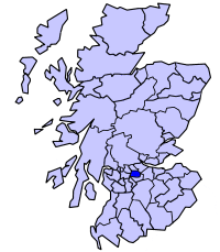
The dark blue area reflects the location of the
original New Monklands District within Scotland.
| Geography | | Status | District | | History | | | Created | 1975 | | Abolished | 1996 | | Succeeded by | North Lanarkshire | | Politics | | | Governance | Monklands District Council |
The name of "Monklands" originated in the grant of lands in the area to the monks of the Cistercian Abbey of Newbattle, East Lothian in 1162. From the seventeenth century the area was formed into the two parishes of New Monkland and Old Monkland.
Note:
The informational article below originated at:
MonklandsOnline
Monklands
The Monklands area we will be referring to is not the old "Monklands District Council" area, but is based upon the original area owned by the Monks. The towns in the list opposite are not representative of the area.
The name of Monklands dates back to 1323 (the name was first recorded in the Steward's Charter of the year) but there is evidence of settlement by hunter-gatherer tribes as far back as the Mesolithic Age (c6500-4000 be). Bronze Age remains have been discovered in the area, and there is an Iron Age Crannog site in Lochend Loch. The area roughly corresponding to the old Monklands District was gifted by Royal Charter of King Malcolm IV to the Cistercian Abbey of Newbattle in 1162. Over the years the monks leased their land to private individuals and at the time of the Reformation the whole area passed into private ownership.
In the year 1162 King Malcolm IV gifted, by Royal Charter, to the Cistercian Abbey of Newbattle, all the land that was later to became known as Munkland or Monklands. In 1224 this was confirmed but now also mentioned the land that lies along the (Clud) Clyde at Kermil or Kermyle (Carmyle).
The Monks of Newbattle farmed most of the area and used the western part of the area for the cultivation of grain while the eastern part was largely used for pasture. They set up a sheep grange at (Drumpeleder) Drumpelier) they built corn mills at Kippsbyre, Gartlea, East Gartmillan, on Rosehall Estate near Carnbroe. They distributed their products along roads they created from Dumpelier to Newbattle Abbey in the east.
The Monks Road entered the Monklands from Torphichen, on the Auchengray estate, passing to the north of the mansion house then along the Hillhead of Eastfield and the estates of Caldercruix, Arden, and Arbuckle, through Browniesside Farm till it entered the lands of Colliertree, along Aitchison Street (the Hogs Back), turned north at what is now Manor Drive (parallel to the aptly named MonksCourt Avenue), past a small pond on the Airdrie estate, across "The Moss", past Kippsbyre. Here the road is believed to have forked, the main route to Drumpelier continued west, crossing the Northburn at Kippsbrig, along Burnbank Street, Sunnyside, crossing the Luggie Burn at (old Coatbrig along Buchanan Street until it entered the lands of Drumpelier at Langloan.
The other route went down Yetts Hole Road to the tithing centre at Kipps. (Yetts Hole Road leads to the Cromlet farm and the locals always refer to Yetts Hole Road as the "Cromlet"). The monks would have also used a route which forked at the Red Bridge, over Dunbeth Road, through High & Low Coates, Coathill, Shawhead on their way to/from other mills in Carnbruth (Carnbroe) and Rosehall.
Over the years the monks leased out portions of their land to private individuals. They set up a courthouse or chapel and a tithing centre at Kipps (known at various times as Kyps, Kip or Kyp or Kippis), on the banks of Cullen's Burn (named after the long gone Cullens Farm), not far from the Cromlet (on present day Kipps Farm).
Note:
Cullen's Burn is formally called
the Gartsherrie Burn.)
The chapel was used more for civil than religious matters and was last used in 1740. In it they held, annually, three principal Baron Courts, at which they collected the rents or tithes of such farms as were let by them to tenants. It assumed extensive judicial rights, civil as well as criminal. Civil matters included adjudication in matters of debt, prices, and work within the area. Criminal matters included trials of all crimes committed in the area. The chapel was destroyed in the late 1700's and the ruins were completely removed by an enterprising farmer in the latter part of the nineteenth century to make way for a cornfield.
Most of the area around the north of Coatbridge and Airdrie was known as Kip or Kyp or Kipps. It is believed that Kipps land extended to Coatdyke in the south and to Whinhall in Airdrie. Around the time of the reformation all the land passed into private ownership.
The Monks were the first to mine coal in the area. In the 1400's a visiting dignitary witnessed "black stones" being distributed to the poor as alms. In the 1500's these stones had become known as "black gold".
Around 1650 the Barony of Monklands was split into two parishes:
New Monkland which encompasses Airdrie and surrounding villages to Slammannan in the east. The North Calder water forms its southern boundary.
Old Monkland is a parish of the Middle Ward in North Lanarkshire. It contains the towns of Baillieston, Coatbridge, and Whifflet and Rosehall, with two-thirds of Calder, seven-eighths of Coatdyke, and one-seventh of Tollcross, as also the villages of Bargeddie and Dykehead, Braehead, Broomhouse, Calderbank, Carmyle, Faskine, Mount Vernon, Swinton, West Maryston, etc. In shape resembling a rude triangle with northward apex, it is bounded NW by Shettleston, Cadder, and New Monkland, NE by New Monkland, and S by Bothwell, Blantyre, Cambuslang, and Rutherglen.
Agriculture remained the main industry up until the late 1700's when the Monklands started mining. Coal and Ironstone were being found on almost every farm. The Monklands Canal was developed to transport the minerals to suitable markets. The Iron industry flourished with the availability of the coal and the Blackband Ironstone. This created a boom in building and quarrying began to meet the demand for the increasing population. Bricks were needed for housing, factories and furnaces - brickworks sprang up in almost every area.
The Industrial Revolution had reached the Monklands.
Coatbridge was rapidly turning into the Iron Burgh. Other villages devoted to mining or quarrying sprung up all over the area - Annathill, Plains, Glenmavis, Longriggend and Baillieston.
MONKLAND PLACE-NAMES
Peter Drummond, Airdrie, spoke of the research he had done for his booklet of the same title, stressing the importance of linguistic context and early forms for each name, the assistance given by occurrences of similar names elsewhere, and the theoretical and practical help given by books like W.F.H. Nicolaisen's Scottish Place-Names (1976) and by professionals like Ian Fraser. The Monklands is no more; the area researched in the 1980s was swallowed up into North Lanarkshire in the 1990s.
It includes Airdrie,
a Gaelic name (there are 3 other Airdries in Scotland) and means either ard ruighe 'height of (the) slope' or ard ýirighe 'height of (the) sheiling', both of which would apply, especially the former, describing the slope down from the Slamannan plateau, a reminder of how important it is to fit a
name into its landscape-context. Being Gaelic Airdrie represents c.25% of the area's names. Most of the others are Scots, with no Norse, Pictish or Anglian names, and only a tiny number of Cumbric ones, like Papperthill. Hence the suggestion is unlikely that 'Airdrie' is Cumbric, containing as its second element Cumbric tref 'farm-stead'.
Coatbridge
Contextual clues also apply to the attempt to find the meaning of Coatbridge, first recorded in 1750. Research has shown that from the 13th century the land was owned by the Colt family, sometimes known as Coats, and the estate generated place-names such as Coatdyke, Coathill, Coatbank and Nether and Over Coats (!). So Coatbridge was simply the bridge on the Coats estate.
Other points touched on included the fact that Gaelic names here appear to be the southern limit of the Central Belt's Gaelic, since much of Lanarkshire southwards has very few; that Gart- ('farm, enclosure for arable') names (e.g. Gartsherrie) are very numerous; that Drum-names are regularly applied to low hills right across the Central Belt; and that the area's farm-names, extant and extinct, are a rich vein of Scots names (e.g. Auldshiels, Palacerigg, One's Mailling, Townhead and Laverock Knowe).
He also gave example of myths about local names: Bargeddie, a village on the banks of the Monklands Canal, is not for example named after a bargee named Edward, but comes from earlier Balgaddeis (1587). Balgedy (1654), Gaelic baile 'farm' + gead 'strip of arable land', and coined long before there was a canal.
He concluded by looking at spoken, unmapped names, like the long-gone tram terminus in Airdrie still known as 'The Terminus'.
Monklands, a former mining and industrial area, had many of these spoken names, such as pits called The Hard Egg, The Wee Jean, and the Hoor in the Park (respectively for the nature of the rock, the intemperate foreman's virago wife, and the improper name of the colliery officially known as 'Lady Anne', properly named after the wife of Sir John Wilson!)
Note:
Also, please visit the Monklands' Timeline.
Monklands history is presented in chronological
sequence.
  
|